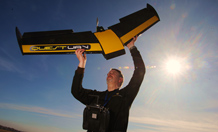
Nigel King of Quest UAV on Exmoor with the aircraft. Photo by Gareth Williams.
Aerial survey reveals Exmoor's rare peatlands as never seen before
An unmanned aircraft has captured hundreds of images of Exmoor’s peatlands, revealing the condition of this rare environment as never seen before.
Flying 300 metres above the ground, the state-of-the art remote-controlled vehicle captured very detailed photographs of two five-hectare study sites.
The University of Exeter and South West Water will use the images to monitor the effectiveness of the planned restoration of these rare ecosystems. The research will investigate whether the restoration, due to take place later this year, will result in improved water storage in the blanket bogs, bringing benefits such as cost savings on water bills and improvements in river quality.
The aerial vehicle can capture up to 200 images, at a rate of one per second, using its built-in cameras. The cameras used are sensitive to both visible and infra-red light, allowing incredible detail to be captured. A team of scientists from the University of Exeter will now use the data to build up a detailed picture of the spatial patterns of the plant life of the peatlands and their biochemical properties. The Exmoor Mires Project research team will use the images to assess the patterns of different species currently living in these habitats, so they can compare this with aerial surveys conducted after restoration.
Known as ‘blanket bogs’, these habitats are globally scarce and 20 per cent of the world’s blanket bogs are found in the UK. On Exmoor National Park, blanket bog and peat cover the central moorland, but have been degraded by centuries of moorland reclamation, agricultural drainage and domestic peat-cutting. The restoration will involve blocking drainage ditches using sustainable and local materials, 're-wetting' the bog and potentially improving its ability to retain water.
In its natural state, a bog stores water, and during periods of heavy rainfall, it slows down the run-off of water from land before steadily releasing it as groundwater. This reduces the ‘scale of fluctuation in river flows, reducing the risk of soil erosion and the amount of sediment entering rivers. Water carrying less sediment is up to 20 per cent cheaper to treat so the research will establish whether water treatment costs may be reduced as the restoration ensures cleaner water leaves the upland bogs.
The ultimate aim is that fully functioning, restored blanket bogs will bring down the cost of downstream treatment of the water. This will potentially avoid water bill increases in the longer-term and aims to improve water security for the region under growing concern about long-term patterns of drought related to climate change.
The survey will also assess whether rewetting the blanket bogs will support more plants, rare insect and animal species.
Dr Karen Anderson is an expert in remote sensing and is based in Geography at the Cornwall campuses. She said: “This is a fantastic opportunity to use aerial surveying technology in a new and innovative way. We are the first team to survey Exmoor’s blanket peatlands using unmanned vehicles and it is exciting to be leading the way and breaking new ground through our research. It is very rewarding to be applying my expertise in remote sensing to a project that could have considerable benefits for people and wildlife.”
Martin Ross, from South West Water, said: “Our Upstream Thinking Project is at the cutting edge of how water is managed in a sustainable way in the UK. This unmanned aircraft is going to help us collect evidence which will show whether mire restoration is succeeding in its aims, and is an extremely cost-effective way of collecting that data. We’re delighted to be working with the University of Exeter on this trial.”
Date: 14 March 2012
