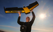
Remote-controlled aircraft are revolutionising ecological data collection. Image courtesy of QuestUAV.
Miniature aircraft could help scientific data take off
In their most basic form, remote-controlled aircraft are the perfect gadget-lover’s toy, but now their high-tech cousins have the potential to revolutionise the way ecological data are collected.
Dr Karen Anderson, of the Environment and Sustainability Institute (ESI), at the University of Exeter’s Cornwall Campus, has been exploring possible new uses of the technology in work published in the journal Frontiers in Ecology and Environment.
Dr Anderson is a specialist in remote sensing, and is part of a team that has won awards for using Unmanned Aerial Vehicles (UAVs) to monitor Westcountry landscapes, specifically the impact of restoration of degraded peatlands on Exmoor.
The technology behind UAVs has evolved to the point where they are more affordable than ever before, and scientists are beginning to use them to carry recording devices for a range of purposes. They allow a level of detail and flexibility not previously possible with data collected via plane or satellite. It gives scientists the ability to carry out sensitive monitoring, such as recording wildlife from above without the risk of disturbance, or capturing bird’s-eye-view footage of landscapes in enough detail to identify individual plants.
The aircraft can be programmed to revisit the same flight path at pre-determined intervals. They are lightweight, but strong enough to carry cameras or sensors which can collect detailed information such as images or thermal data.
Dr Anderson said: “UAVs have been the subject of some negative headlines recently, but from a scientific perspective, there is a really positive story to tell. They can fly low and slow over the landscape and can be used to collect very detailed pictures of a precise area. The fact that UAVs are now quite affordable means that researchers can have full control over collection of their own data. In the past, we have had to rely on aeroplanes or satellites for images, but these can often be affected by poor weather conditions and clouds, that block our view of landscapes from high altitudes. With UAVs, we can more easily select the optimal days on which to fly and we can fly under the cloud base, so there are potentially more opportunities for data collection.
“Spatial ecology and environmental sciences have long been hampered by limited technology and budget restraints. This technology is really taking off as an extremely powerful tool, and has the potential to revolutionise research.”
Dr Anderson concluded that UAVs have huge potential to change the way scientists work, enabling them to use thermal imaging cameras to monitor nocturnal animals such as deer. The technology could even carry 3D sensing equipment, which could help build up images such as the internal structure of tree canopies.
The research was supported by the European Research Council under the European Union’s Seventh Framework Programme.
Date: 2 April 2013
