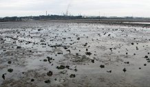
Fish weirs are permanent fishing structures, built from wood or stone to marshal fish into a single area where they can be collected.
Ancient fish trap gives new clues about history of erosion on Britain’s coastline
An ancient Saxon fishing trap exposed for the first time in centuries thanks to radical environmental change has provided new clues about the history of coastal erosion in Britain.
The discovery of the fish weir reveals the advance and retreat of salt marshes over the centuries.
The weir, found by chance by experts surveying Southampton Waters, has allowed them to map alterations to the shoreline over a thousand years. It also reveals how medieval communities found a way of exploiting natural resources, perhaps to feed developing urban areas nearby.
Fish weirs are permanent static fishing structures, built from wood or stone to marshal fish into a single area, a pound, where they are trapped and collected by hand or net. Most are designed to catch the fish when the tide ebbs. Radiocarbon dating shows the weir was built in the eighth or ninth centuries, in the middle Saxon period.
Dr John Cooper, a marine archaeologist at the University of Exeter, and colleagues working in Greece, the Netherlands and Italy, believe the weir was built to make large catches then delivered to consumers by boat. When the tide was in it filled with salt water. Analysis shows coastal changes meant the foreshore and weir then became covered by advancing salt marsh. Later this salt marsh retreated, exposing the weir. This suggests that salt marshes have been in a state of flux for at least the last 13 centuries.
The researchers carried out their analysis by comparing different Ordnance Survey maps of the coastline, near Ashlett, since 1898. They then made their own survey also used remote sensing technology to monitor change in the nearby saltmarsh cliff edge. They found it has been subject to a marked and ongoing regression in the past 100 years.
The surveys show the salt marshes grew at some point after the weir was constructed but then, at some point before 1898, started to retreat again. The fish weir and its traps were buried under salt marsh until around 50 years ago and then became exposed as the marsh retreated and the mud that covered them eroded away.
As well as showing changes to the coastline, the discovery provides a new insight into how the Saxons used the waters near Southampton. Hamwic, the Saxon urban precursor to Southampton, developed as a royal town, was then emerging as a prominent political centre, and the weir shows communities in the rural hinterlands were using technology to exploit natural resources that could have supplied the town.
It is not known who owned the weir. But records show many were owned by the church before the Reformation. The weir is similar in construction to another built around the same period on the nearby Isle of Wight. It was probably operated by a local community, who used their in-depth knowledge of fishing to collect two hauls every 24 hours as the tide came and retreated.
Dr Cooper said: “It is rare to be able to analyse a weir from the Saxon period as few remain, and we are lucky that we spotted the exposed wooden stakes when we were carrying out other research in this part of Southampton Water. We are concerned that it might not survive, and we have seen it eroding over the 12 years we have been surveying the area.
“We now know we only found the weir because the saltmarsh has been retreating since the nineteenth century. This discovery tells us much about the changes to the coastline in the area, it acts as a useful reference point for scholars of climate change, sea-level rise and coastal erosion.”
Date: 19 July 2017
